Drone Update - One Year On
This time last year we wrote a blog post on our drone service, which we set up in the previous year. We’d been trialling the drone for usefulness on our projects (beyond the obvious aerial photos). So another year down the line and we’ve learnt a whole lot more and wanted to share that.
There were a couple of things we have focused on and talked about in our first blog post, this how we got on:
“High quality aerial imagery: both stitched aerial photos (orthomosaic images) encompassing the entirety of a site as well as individual photos focussing on areas of interest.”
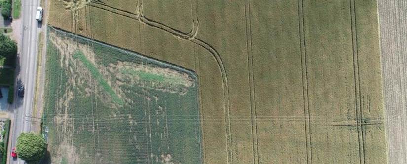
We’ve found the high quality imagery to be a really useful benefit, but taking photos was never what we intended the drone’s main purpose to be. There’s a lot to be said about aerial photos of any site at walkover stage; we’ve spotted things at this early stage that have allowed us to give the client a heads-up on potential issues that could become an extra cost during the project phase giving them extra time to plan and cost up. The stitched together aerial imagery (orthomosaic) is particularly good for getting an up to date site plan (as opposed to what you’d get from freely available satellite imagery) and comes to its own on large sites, such as in this case study. Boreholes, trial pits and other exploratory hole / test locations can be annotated on up-to-date site plans and if a survey is completed before and after site works, our clients can rest easy to see that we haven’t left lots of holes in the ground for people and animals to fall down. Accurate coordinates / positions of any other notable features such as trees, ponds or stockpiles can also be obtained from the data collected by the drone so that the wider project team can plan their operations accordingly.
“Elevation data and elevation models can also be generated through data collected by the drone and EPS are particularly keen to explore this capability in tandem with our well established flood risk assessments (FRA’s) and drainage capabilities.”
The elevation data provided by the drone has pretty much been as good as we expected. You can imagine the time savings on a site such as a large field compared to a traditional topographic survey. Limitations here include things like dense vegetation and even tall grass so you do need to know what you’re doing to get meaningful data.
“For our architects and BIM (building information modelling) experienced friends we’re also offering 3D models which can help in design elements and can focus on structures, terrain or other features such as slopes or stockpiles, for example to estimate volumes to supplement materials management plans (MMP’s).”
The 3D modelling has been extremely useful on projects where we’ve prepared MMPs (materials management plans) for our clients. We’re essentially calculating volumes of stockpiles of soil here as well as estimating the volume of materials that will be available after demolition / groundworks for example by taking measurements of concrete slabs or areas of tarmac. The drone has allowed us to quickly and accurately calculate volumes, map locations and track changes on these sites at the same time. To date, we’ve not had the opportunity to generate models of any buildings for any of our clients, but we’re hopeful that in the future we can provide this service for some of our atypical clients. We’re also hopeful that more of our clients will ask us to capture imagery for use in the marketing of sites.
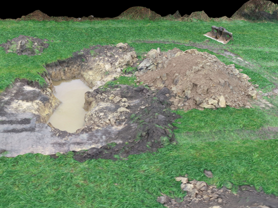
We have found uses for the 3D modelling element of the drone useful in areas that we didn’t initially consider. For example, a 3D model of several large scale trenches and excavations on a site with historical coal mining legacy allowed for the identification of individual bricks associated with a known coal mine shaft as well as historic drains. The dimensions of these features could then be accurately measured through GIS (geographic information systems) software avoiding the need for anyone to get close to the edge of excavations potentially falling in – score one for health and safety!
Screenshot of 3D model of excavation around a historic mine shaft.

Other notable (and geeky) updates:
- In the short 12 months + that we have been using our drone to provide our clients with a range of useful information, several changes have been made to the relevant documents governing the use and operation of drones for commercial (and recreational) applications (including the Air Navigation Order and Civil Aviation Publication (CAP) 722). These changes have been implemented into our operations and systems manuals and have been positively received by EPS’ pilots and staff. In the near future we’re preparing for some more mandatory changes which will affect our standard operating procedures. These changes will see the registration of all 'drones and model aircraft from 250g to 20kg that are used outdoors’ with the Civil Aviation Authority. Here at EPS we are committed to maintaining our safety performance targets to ensure that no injury to any persons or damage to any property (or our beloved drone) occurs as a result of our drone operations.
- We’re currently in the process of repackaging the data "bundle" that we deliver to clients into a more manageable and standardised package for efficient delivery to clients and their wider project teams. We’re hoping to have this more manageable dataset from drone surveys ready by the New Year - so watch this space!
- We have also found the high precision RTK (real time kinematic) GPS, that we use in tandem with our drone to maximise accuracy, to be very useful for non-drone applications such as locating historic monitoring wells and in internal training illustrating the differences in relative (local) accuracy and absolute accuracy and the variation in GPS accuracy across a range of different devices. In addition to being a handy real-life v.s. theory demo tool, this device has already allowed us to help our clients by providing precise coordinates for previously unidentified features on site at the late stages of developments.
If you'd like to find out more about the EPS drone service, your contact to speak to is Tom.